TwoNav Premium: Maps Routes app for iPhone and iPad
4.4 (
7824 ratings )
Sports
Navigation
Developer:
CompeGPS
9.99 USD
Current version:
5.9.2, last update: 9 months ago
First release : 29 Dec 2009
App size: 55.62 Mb
TURN YOUR SMARTPHONE INTO A POWERFUL NAVIGATION SYSTEM
Explore your environment with the best maps, travel the most spectacular routes, improve your performance and, above all, practice your outdoor activities in complete safety. Take your outings to a new level.
_______________________
ADAPT THE APP TO YOUR SPORT
TwoNav can be adapted to different sports, such as hiking, cycling, motor sports, flying, water sports... Create your profile and the app will adapts its configuration to this sport. Do you practice other sports? Create different profiles.
_______________________
EXPLORE YOUR SURROUNDINGS DOWN TO THE SMALLEST DETAIL
Load multiple maps at once and view them at the same time or alternately. Move the map freely to find the best perspective. Discover new points of interest near your current location.
_______________________
SAFE EXPLORATION
Follow your route and keep under control the distance, time and ascent to reach your goal. Explore routes created by you, downloaded or calculate your route automatically. The App will notify if you deviate from tour course or if you run into something unforeseen.
_______________________
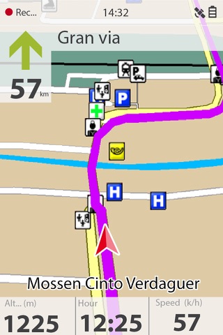
SIMPLE AND INTUITIVE GPS NAVIGATION
Forget the old roadbooks on paper. Your roadbook is now digital, everything you need to know is on the screen of your smartphone. The App tells you turn by turn which road to follow.
_______________________
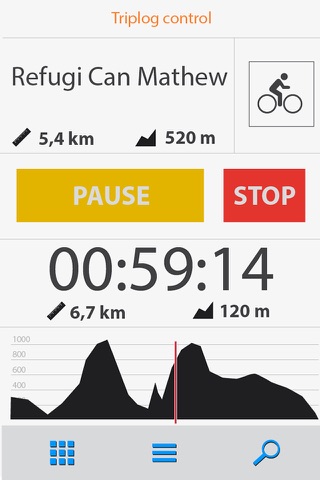
TRAINING TOOLS
You decide whether you train by time, by distance... or compete against yourself with TrackAttack™. Improve your performance from a previous training session. The app tells you whether you exceed your previous performance or whether you need to improve.
_______________________
CREATE YOUR OWN ROUTES AND WAYPOINTS
Create routes and waypoints by pressing directly on the screen, organize them in folders and collections. You can also enrich your references by adding photos and videos.
_______________________
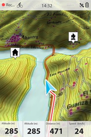
3D VIEW FOR MORE REALISM
Just before you leave home, turn your 2D maps into a 3D view. Plan the difficulty of the terrain you will be entering to with a very realistic simulation.
_______________________
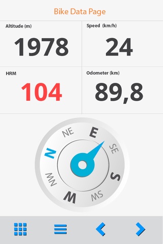
OPTIMIZE YOUR PERFORMANCE
Monitor the most relevant data of your activity such as distances, speed, times and altitudes. The App will show data for what you have covered so far and what is still ahead of you.
_______________________
VISIBLE AND AUDIBLE ALARMS
Set how far you want to go, set alarms, the app will warn you if you exceed the limits you have set (heart rate, speed, altitude, route deviation...).
_______________________
BROADCAST YOUR LOCATION LIVE
With Amigos™ you will be able to share your location live wherever you are. This ensures your safety and that of your loved ones.
_______________________
DETAILED ANALYSIS OF YOUR ROUTES
Back at home, analyze your routes with detail and accuracy. Relive every stage of your adventure with graphs, laps, +120 data fields...
_______________________
CONNECT WITH THE WORLD
Keep your activities in a safe and accessible place thanks to the GO Cloud (30 MB free). Connect to other services such as Strava, TrainingPeaks, Komoot, UtagawaVTT or OpenRunner, synchronize your activities or download your best routes.
_______________________
IMPORTANT
The acquisition of this App through iTunes does not allow installation on other devices different that iOS operating systems.
Pros and cons of TwoNav Premium: Maps Routes app for iPhone and iPad
TwoNav Premium: Maps Routes app good for
The reason to jump up and down about this app in the USA is simple... The Off Road and Offline GPS features are really unparalleled on the iphone. OK so you have a fully functional tracking 3D GPS with all the free maps, topos, and imagery you would expect. It also has a very nice clean simple interface (once you get used to it). OK so what I am so enthralled with is that you have the unique ability to load your own maps into this GPS software making this a 4 star app off the bat. The gold nugget, is that these guys also have an optional software programs Land 7.0 which will help you edit offline maps, pull free maps, compare, edit and calibrate maps/imagery and a ton of other cool mapping kinda stuff... and then Land 7.0 lets you save and load your maps/images right onto the iphone for use in TwoNav. If these guys get routable On Road maps for the USA this would be an easy 5+star rating and a grand slam !!!!
I love the app. I only wish it came with better operating instructions and a way to convert other map types. I needed to to download a map I had in a .PDF format and I had to purchase compegps to do the conversion.
TwoNav for iPhone is one of the best "real" GPS applications I have seen in years from any company on any hardware. The feature set is amazingly rich for both Off-road and On-road navigation - hence, Two Nav, get it! The application layout is easy to master and the on-screen data is highly user configurable. TwoNav (CompeGPS) understand what features are necessary to navigate during various activities and have managed to accommodate most. I found it easy to import/export data (Waypoints, POIs, Tracks, Routes, Maps) using the built-in FTP Server - very handy.
You can purchase Routable Vector maps for Europe but there are none for North America. I think this will significantly hinder TwoNav sales since it reduces the feature set in North America to One Nav (non-routing). I must say I am looking forward to the native iPad update though. This app gets 5 Stars when I can purchase routable NA maps.
UPDATE:
I said Id give this 5 stars when NA routable maps were available.
Although Im a bit disappointed with the TeleAtlas map data. Not even close to what is available forum other map companies with regard to secondary and backcountry roads. POIs are basically nonexistent.
In general I still havent found a better full featured nav app.
First I. Thought I was going to waste a lot of money.then one day I took it outside and it work better then a pro gps.
Some bad moments
Ever since the app was released, it had problems problems problems!!!
as reported earlier, the latest version does not connect to GPS anymore.It does not show position and does not record tracks. As such the app is now useless!!
I hope this will be fixed very soon …
I have spent quite a lot of money and thought I get good topo maps of Poland as described. The maps are comparable to google maps. No touristic signs, no touristics routes. Total disaster comparing e.g to Garmin I used last few years. Dont buy this app!
In general not bad, since it allows to use raster maps on iPhone and iPad. But logging tracks (so called triplog) in general does not work. Every time and again afterparty a while application stops writing tracks, or adds bizarre artefacts, i.e. points that are far away from the actual position (eg. 10 km. away). Another irritating bug is that loading more than a few (7-8) raster maps crashes the application.
To sum up - if you want to use ipad as a simple map, the application may work for you. If you want something more you will be disapointed.
This product has a lot of potential, but for 65$ I expect more.
1. Add retina display support for iPhone 4. Currently, the UI looks horrible!
2. Use the iPhone built-in keyboard UI instead of the one currently used and add support for international keyboards (like Hebrew).
3. Make the settings more user friendly. Its current order is not intuitive.
4. Add a Mac version for the Land application. Mac users want to export maps to iPhone too!!!
To conclude, TwoNav is a good GPS app, but for 65$, I would let the developers make it more iPhone friendly before buying.
Im sad that I wasted my money... GUI is extrapolated from iPhone app.
after start up I downloaded the suggested map base, I think my 386 was faster 16 years ago...